by Skip Via
skip@westvalleynaturalists.org
Editor’s note: In an earlier post on our website (Water Water Everywhere?) I discussed the nature of our valley water resources. Our groundwater comes from two sources–the shallow, unconfined aquifers that are replenished by precipitation, and the deeper confined aquifer from which Kalispell’s municipal water and most of the water used for irrigation in the valley is drawn. None of our water comes from reservoirs. (Whitefish gets its municipal water from Whitefish Lake.) A review of that article might provide good context for this article.
The intent of this article is intended to stimulate thought, not to advocate for a specific viewpoint. To that end, some assumptions, disclaimers and caveats:
- I’m not a hydrologist, climatologist, or a geologist–just an interested observer;
- Weather can change quickly in these parts;
- Weather and climate are not the same thing;
- I don’t know the answers to the questions I am posing.
It’s not difficult to see what a critical force water has been in the geographical and habitation history of our valley. If we didn’t have access to abundant water resources, both above and below ground, we would not be the agricultural center that we are now. And if it weren’t for glaciers, snowpack, and rushing rivers and streams, the landscape around here would look a lot different. There probably wouldn’t even be a place level enough with sufficient soil to farm at all.
Take a look at this Google Earth view of the Flathead Valley.
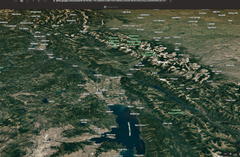
Glacial action and the melting of the Cordilleran Ice Sheet 15,000 to 13,000 years ago carved huge valleys through the rocky terrain, deposited mineral-rich soil in the valleys, and established huge rivers, smaller waterways, lakes and ponds that have supported wildlife and people since that time. There was once a LOT of water here, in liquid and solid form.
Here’s a closer look at the West Valley area of the Flathead.

Notice all the small kettle ponds, sloughs (wet and dry), rivers, and former river channels that dot the landscape. Their presence is a direct result of the end of the last ice age. The huge volume of water/ice that drained out of our valley left them behind. An historically consistent post-glacial climate, particularly in terms of annual precipitation, replenished those ponds and waterways from year to year by creating mountain snowpacks and replenishing glaciers. Not every year, because weather patterns can change dramatically over short periods of time. But for the most part, access to abundant water has never been a problem.
But it’s not at all difficult to look at the picture above and see and a landscape that is drying up. When it rains at my house, the initial introduction of water runs down my driveway like a small stream. But over time, as the source of that water goes away, the water forms smaller and smaller rivulets and pools that eventually shrink through evaporation, drainage, and lack of replenishment. I can see that same phenomenon in the picture above. The source of the water that used to course through our valley has been significantly reduced, leaving a variety of telltale traces. That makes sense. The 4,000+ feet of ice that used to cover our valley melted and had to go somewhere, and over time more and more of that water has left the valley. But are we at a point of stasis, or are we still losing water? Will the future be drier, like my driveway when the sun comes out?
Let’s think about that in the context of the 2+ decades-long historic drought that most of the western United States is enduring. Here is a list of the major rivers that flow across the US west (defined here as in and west of the Rocky Mountains) and the states through which they flow, ranked by length of the main stem, longest first:
| River | Mouth | States |
| Missouri | Mississippi River | Montana, North Dakota, South Dakota, Nebraska, Iowa, Kansas, Missouri |
| Rio Grande | Gulf of Mexico* | Colorado, New Mexico, Texas |
| Colorado | Gulf of California* | Colorado, Utah, Arizona, Nevada, California |
| Arkansas | Mississippi River | Colorado, Kansas, Oklahoma, Arkansas |
| Snake | Columbia River | Wyoming, Idaho, Oregon, Washington |
| Green | Colorado River | Wyoming, Colorado, Utah |
Now think about this: The following states–Arizona, New Mexico, Colorado, Nebraska, California and Idaho (in bold, above)–are using more water than they receive each year through replenishing precipitation or melting glaciers (Source: World Resources Institute). That gap is the result of several factors: agriculture, manufacturing, household uses, and prolonged drought due to climate change. But because of this situation, less and less water is entering the west’s waterways and aquifers as each year passes.
Only 3.5 percent of the Earth’s water is drinkable. Sixty-eight percent of that is trapped in glaciers and ice caps, mostly in Greenland and Antarctica. Thirty percent of Earth’s fresh water is underground, much of it deep enough that it is not accessible. (See Water Water Everywhere?) According to research, about half of the water in our underground aquifers will be depleted in the next 40 years (Source: Colorado State University.) We’ve pumped and redistributed so much groundwater (2,150 gigatons between 1933 and 20I0) that we have affected the tilt of the Earth on its axis (Science.org). I am not able to find any current information on the level of depletion/replenishment of our Flathead Valley aquifers, but I do know that the Deep Aquifer is the source of all of Kalispell’s municipal water along with most of the valley’s irrigation systems and domestic wells.
So, where does that put us here in West Valley?
These are important questions for our valley, not to mention the rest of the world. In the western US, we’ve seen a steady drain on water resources over the past century or so. The Colorado River no longer flows to the Gulf of California. The Rio Grande dries up before it reaches the Gulf of Mexico. Aquifers in Nevada, California and neighboring states are being depleted and wells are failing. Aquifers can be replenished, but it takes time. And lots of water.
Here in the valley, it’s clear that our surface water resources have diminishing over time due to a variety of factors. The warming climate and steady population growth suggests to me that we’re not in a period of stasis in that regard but that we will continue to lose surface water resources. The Deep Aquifer under West Valley is large, but it’s not infinite, especially when replenishing sources of water are becoming more scarce.
So, are we drying up, or are we just experiencing a pendulum swing that will eventually return us to a period of more stasis and balance? I don’t know, but I think it’s a question worth asking, and probably worth devoting some long-term planning to.
Another source of information to get facts about water resources drying up, is to ask the well drillers. If you get lucky enough to talk to some, they all have the same answer why so many wells are drying up in the valley. More people,more wells, less water.
Good point. We have a community well where we live, and the technician that did some repairs recently confirmed that wells in the valley are indeed drying up. It’s a finite resource.