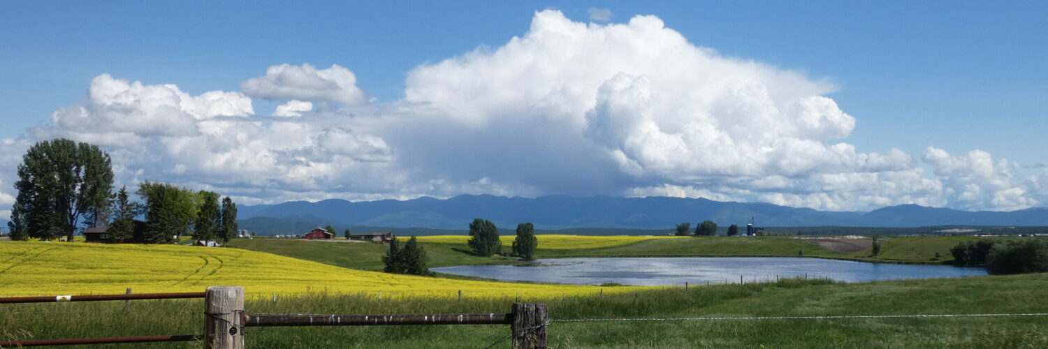
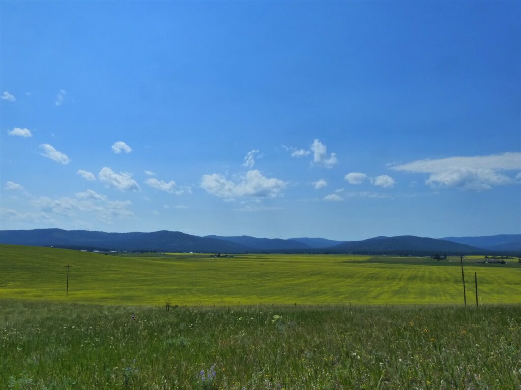
Hemp field on the corner of Coclet and West Valley Drive.
If you have driven down West Valley Drive this summer, you have probably noticed a new agricultural crop growing in a couple of the fields near Coclet. It’s hemp, and I wanted to know more about it.
Editor’s Note: Three days after this post was written, Montana FWP announced an “unprecedented” fishery closure (“hoot owl restrictions”) on the North Fork of the Flathead River due to record high water temperatures and rapidly decreasing stream flow in the absence of any meaningful precipitation this summer.
A year ago, when most of the valley was in the throes of an extreme drought, I posted an article titled Hydrology Snapshot, July 2023 in which I started the process of keeping track of some issues related to water usage, precipitation, and water management in the Flathead Valley.
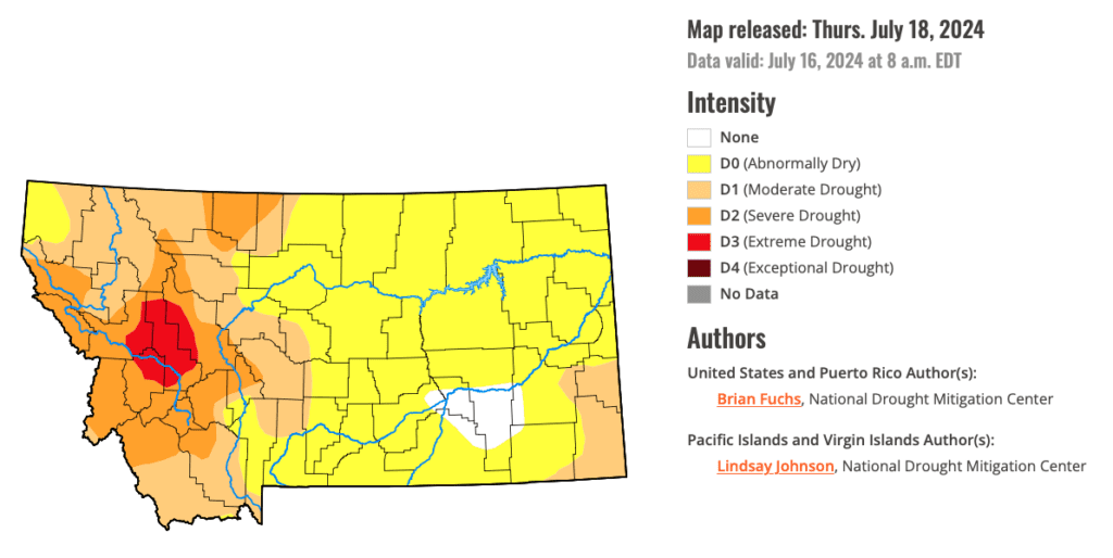
It’s now mid-July 2024. We’re still experiencing drought conditions, but the severity has been downgraded to moderate/severe. Droughts are rated on a 5 point scale: D0 (Abnormally dry), D1 (Moderate), D2 (Severe), D3 (Extreme), and D4 (Exceptional). 99.62% of the Flathead is considered to be in Moderate (D1) conditions as of this writing.
English Inquiry Project by Sawyer S., West Valley School
What is a pollinator and what positive effects do they have on us humans?
What is a pollinator? This is something one may ask themself but not truly know. A pollinator is anything that carries pollen from the stamen to the stigma. This transfer must happen for the plant to produce. From squash to wheat, this is necessary for production. When someone says pollinator, one generally thinks of bees but this is not always the case. Pollinators include wind, water, bees, wasps, moths, butterflies, birds, and even small mammals including bats.
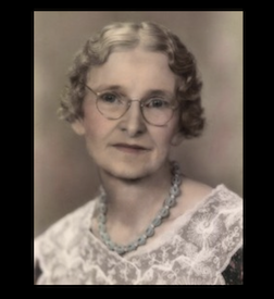
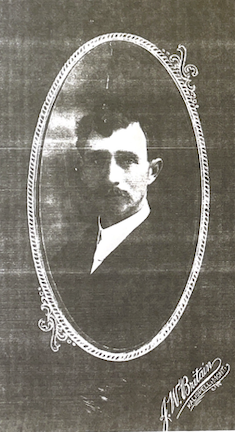
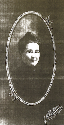
Myron Nicholson was born in Port Byron, Illinois on July 29, 1873. Mr. Nicholson spent his early years farming in Illinois. On November 25, 1900 he married Miss Emma Osborn. That same year he moved to Chicago and engaged in the manufacture of brooms. He then entered the Moody Bible Institute and became a Baptist minister. He served the church at Hubbard, Minnesota in 1903 and at Sherburn, Minnesota from 1904 until 1909 when he moved to Belt, Montana. A year later he moved to the Flathead and bought a farm five miles northwest of Kalispell. He retired from farming in 1937 and moved to Kalispell. He was a deacon of the local Baptist church and substituted as minister on many occasions.
Here is a quick end-of-summer hydrology snapshot as of 9/18/23. (Compare to July 2023.)
Rainfall YTD
-3.4” from average
Flathead Lake Level
-36” (3’) from full pool
Hungry Horse Reservoir
-168” (14’) from full pool
Streamflow, Flathead River
-80 cfps from normal
Snowpack
n/a
Snowmelt
n/a
Despite a welcome August rain (21st wettest August on record) from the remnants of Cyclone Hilary, most of the Flathead Valley is still experiencing “moderate drought.” As of this writing, we’re experiencing the 6th driest year in 129 years of record keeping. Lake levels remain at historic lows. Streamflow in the North and Middle forks of the Flathead River are at “historic lows.” Streamflow in the Flathead River is somewhat mitigated by release from the Hungry Horse dam, which by regulation must maintain a minimum streamflow level for water leaving the dam. That release is causing the water level at the dam to drop.
Local lakes and ponds have benefitted from the August rain. Water levels are noticeably higher than they were in July, but are still far below average levels. Some of this increase is due to runoff, and some is due to the raising of the water table through replenishment of the shallow aquifers that underlie most of the West Valley area.
Editor’s note: In an earlier post on our website (Water Water Everywhere?) I discussed the nature of our valley water resources. Our groundwater comes from two sources–the shallow, unconfined aquifers that are replenished by precipitation, and the deeper confined aquifer from which Kalispell’s municipal water and most of the water used for irrigation in the valley is drawn. None of our water comes from reservoirs. (Whitefish gets its municipal water from Whitefish Lake.) A review of that article might provide good context for this article.
The intent of this article is intended to stimulate thought, not to advocate for a specific viewpoint. To that end, some assumptions, disclaimers and caveats:
I’m not a hydrologist, climatologist, or a geologist–just an interested observer;
Weather can change quickly in these parts;
Weather and climate are not the same thing;
I don’t know the answers to the questions I am posing.
It’s not difficult to see what a critical force water has been in the geographical and habitation history of our valley. If we didn’t have access to abundant water resources, both above and below ground, we would not be the agricultural center that we are now. And if it weren’t for glaciers, snowpack, and rushing rivers and streams, the landscape around here would look a lot different. There probably wouldn’t even be a place level enough with sufficient soil to farm at all.
Editor’s Note (March 2024): In her research, Jeanine came across some interesting information related to the Ashely Creek Ditch. In the 1910 census for the area around the Grosswiler farm on Farm to Market, there was a boarding house with 20 men living in it. And all but two–the cooks in the house–were working on a canal ditch. Almost all of them were immigrants from England, Russia and Germany and in their 50’s, except for one who was in his 20’s. I would say these were the guys that built the Ashley ditch.
The Ashley Creek Ditch was an irrigation system developed in the early 1900s to supply water from Ashley Creek to farms in the west valley area of the Flathead. The Ditch was not a county or state project; rather, it was paid for and maintained by the families that used the water. It’s no longer there, having been dismantled in the late 1970s due to changing agricultural practices and the increasing availability of tapping directly into the aquifers for irrigation. But its story is a prime example of the ingenuity and work ethic that early settlers in the area shared.
Edmond Kelley was born in Wyoming County, Pennsylvania, on April 18, 1860 and was educated and lived in Pennsylvania until coming to Montana in 1885, first locating in Butte and then moving to the Flathead Valley in 1887. He spent his first night in Somers. He was told that the valley farther up had some value as a range for cattle but of no value for farming. The next day he walked to the site that would later become Demersville.
July is filled with awe-inspiring sights; it is hard to decide what is most representative of the month. Fields, forest, hilltops, and more. . .read on to see some of the things that I’ve observed in this busy month.
These photos are of a barn off of Clark Road. The barn is on a homestead that was settled by the Clark family in 1898. The barn itself was constructed in 1909, before there was a Farm to Market Road linking the nascent agricultural area of West Valley to markets in Kalispell.
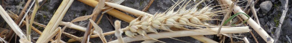
Late August, 2021 Wheat ripening under smoky skies
The historic Ray Kuhns homestead off Farm-to-Market Road between Kalispell and Whitefish is under MFWP management as the Kuhns WMA (wildlife management area). 100 acres of the 1556.5A parcel are leased for farming to improve the soil, control noxious weeds, and provide food and cover to benefit deer and upland game birds. In this article, you can read more about this public resource in our community.
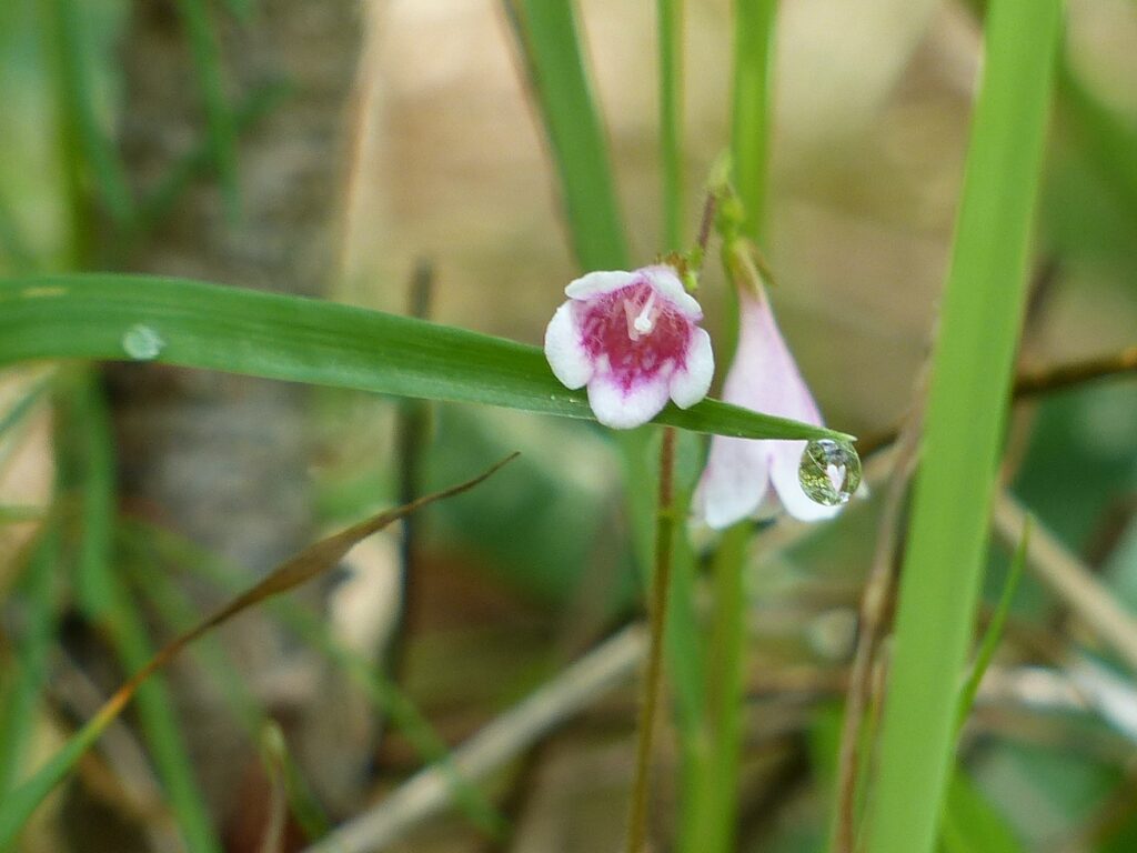
Spring is in full swing! Everywhere you look, something is bursting with color, singing exuberantly, or growing so fast you can almost hear the cells expanding! I could almost hear the bells ringing as I lay in the damp grass looking at a patch of Twin flowers! Here are some of my favorite images taken in the third month of Spring.
Winter is melting into summer. Every day is a surprise: will the snow retreat today? or will we experience a fall-back into freezing temperatures and even get some snow? When will we see some green in the in the cold, black soil of fields that were sown last fall? When will we see the first-of-the-year (FOY) Sandhill Crane? Who can guess correctly the day of ice-out on the potholes? How many geese, ducks, swans fit in the one open pool? Are those trees really starting to blossom? Will I be able to leave that heavy coat home? Read further for some of my FOY’s!
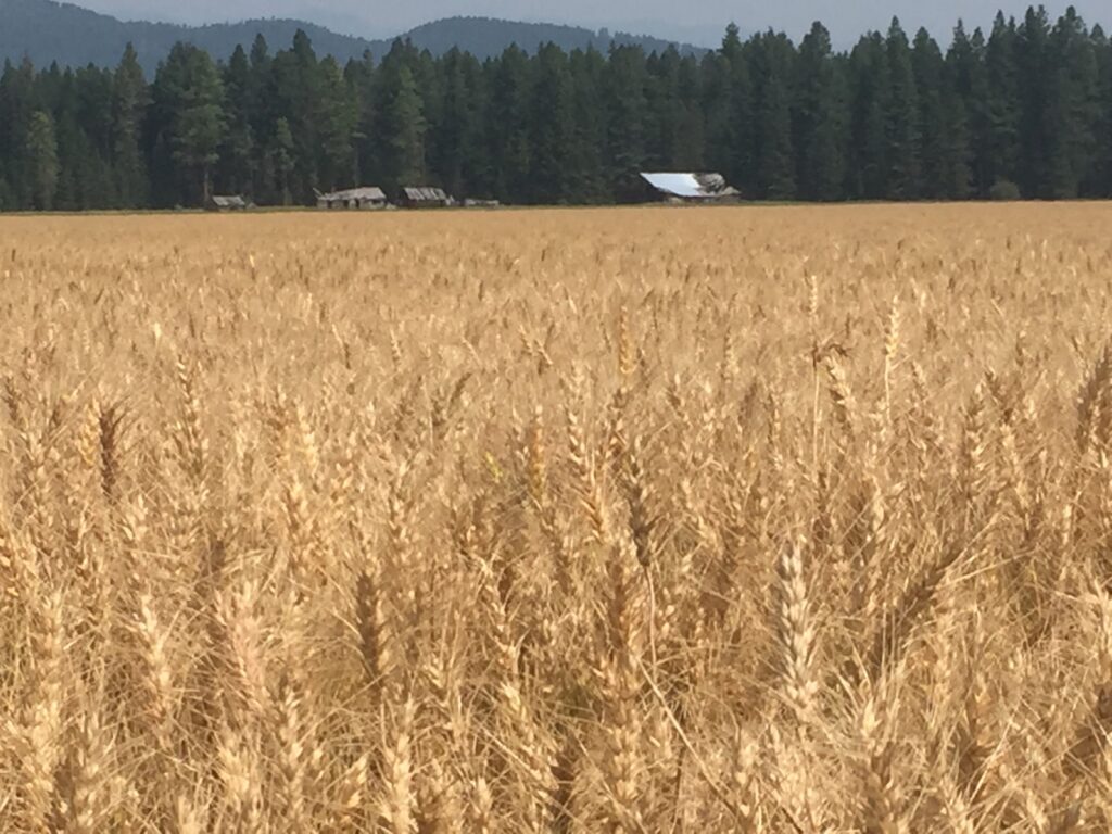
Wheat is grown throughout the West Valley area and is one of the most important crops in the valley. And while most wheat is processed for human consumption, it’s also an important source of food for a variety of local wildlife.