by Skip Via
skip@westvalleynaturalists.org
My intention with this post is to begin a regular documentation of the local effects that hydrological issues have on life here in the valley.
This post from last month–Water Water Everywhere?–discusses some of the hydrological factors involved in how we access water resources for drinking and agriculture here in the valley, including a discussion of the water table and the Deep Aquifer, from which most of our water is drawn. The distinction between the water table and the Deep Aquifer is important. Rainfall, which can alter the local water table either by its presence or absence, does not affect the amount of water in the Deep Aquifer. Please refer to that article for more information.
Here’s a quick Flathead Valley hydrology snapshot from July 4, 2023:
| Rainfall YTD | 5” (avg 9.72”) |
| Flathead Lake Level | 12” below 23-year median, 9” below full pool |
| Valley Sreamflow | 60% below average |
| Snowpack | 86% of average |
| Snowmelt | Fastest in 30 years |
The news for Flathead Lake and local streams doesn’t get any better for the immediate future:
According to Energy Keepers, without substantial precipitation or an increase in streamflows, the lowest level this summer is anticipated to be 1.8 feet below full pool. The lake typically sits close to full pool all summer long…[Energy Keepers] anticipated the drop in streamflows and worked with the Army Corp of Engineers to fill the lake in May when the snowmelt was at its peak. However, May’s warm wet weather brought a below-normal snowpack gushing out of the mountains, leaving just a trickle for June.
Daily Interlake, June 29, 2023
Hungry Horse reservoir–not part of the Flathead Valley, but apropos to the discussion here as the reservoir is subject to the same below average snowpack and early melting–currently sits at six feet below full pool.
Streamflow and lake levels interact in several complex ways that affect wildlife, agriculture, power generation, recreation, and economics, and what’s good for one is not necessarily good for another. For example, the Se̓liš Ksanka Qĺispe̓ (SKQ) Dam on Flathead Lake controls the streamflow of the Lower Flathead River below the dam, while the Hungry Horse dam controls the streamflow of the south fork of the Flathead River. (The north and middle forks are not dammed, so the flow there is entirely dependent on seasonal snowmelt and rainfall.) Each agency is responsible for maintaining a minimum streamflow level to support fish migration and other wildlife issues, and both are currently running at legal minimum levels. But minimum streamflow into Flathead Lake may not be sufficient to fill the lake to full pool, especially if the north and middle forks see increasingly low streamflow, so marina owners’ and boaters’ access to the lake is being compromised. And low water levels behind dams have obvious implications for power generation.
What does this look like in the Flathead Valley?
As of this writing, most of Flathead County is considered to be in “moderate to severe” drought conditions.
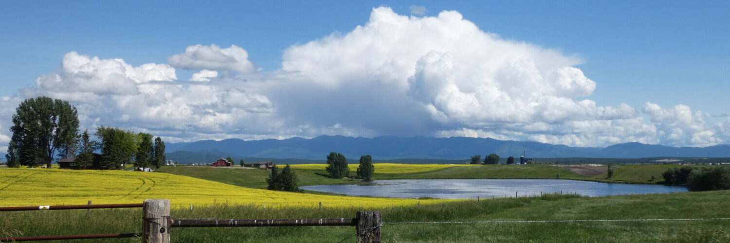
For an example, compare this photo (taken July 3, 2023) with the photo that we use at the top of every page of this website, taken at the same spot at the same time of year five years ago:

The water in the pond at present only in the northern 1/5 of the area it occupied in the top photo. The trees to the far right sat along the shoreline for most of the summer several years ago. Where there were stilts, avocets, ibises, and other waders pacing waters of the shallow end of the pond close to the road, there is now solid ground with several years of growth of ground cover. The loss of water year to year has been noticeable.
While some of this may be due to use of the pond for irrigation (anyone know the answer to that?) it’s likely that case that most of the absence of water is due to lack of precipitation and a consequent lowering of the water table. Temperature increases also contribute to this situation.
Water level in The West Valley Wildlife Viewing Area is considerably below normal, again likely due to a lowering of the water table in the valley. This area is prime habitat for migrating waterfowl and even at full capacity is crowded with a wide variety of species.
Our farmers are also facing the results of an extended drought. From a 2010 study:
Irrigation has traditionally been used to buffer the effects of drought in agricultural communities. However, drought events can still lead to drought damage for irrigators by reducing irrigation water supplies, increasing crop water demand, and creating habitats for invasive pests and weeds. Further, drought will be increasingly problematic in irrigated areas as climate change continues to affect global climates and water resources. The Flathead River basin contains substantial areas of irrigated agriculture including the 128,000 acre Flathead Irrigation Project (FIP). The FIP is the largest irrigation project in Montana as well as the largest of the 16 Bureau of Indian Affairs (BIA) federal irrigation projects…Findings [from the study] show that drought for irrigators in the Flathead River basin is a complex phenomenon. It is physically constructed of processes affecting both long-term water availability and short-term growing season dryness. Additionally, institutional arrangements affecting water management and the economic marginalization of the agriculturalist lifestyle have led to drought vulnerabilities for some irrigators in the basin.
Irrigators’ Vulnerability to Drought in the Flathead River Basin, Montana, by Joel Brown Stephen,UMT ScholarWorks
What’s Coming Down the Pike?
Although conditions can change significantly from year to year–for example, the Kootenai and Flathead drainages had above normal hydrological conditions last year, and Southwest Montana had a near record snowpack this winter along the Idaho border–there are also some longer term climate factors involved. We are at the end of the third year of a La Niña cycle which generally brings average snowpack and precipitation to the valley and at the beginning of an El Niño cycle, which typically means conditions that are warmer and drier than average.
On the global stage, on July 3rd, 2023 the average global temperature worldwide reached a record high of 62.6˚F. That record was broken on July 4th, 2023 with an average global temperature of 62.9˚F.
Our warming climate also contributes to extreme weather conditions. Storms are stronger; rainfall can be more intense; droughts are longer and more severe. While there are several factors in addition to global warming that can influence extreme weather events, the link to global warming as a significant factor is indisputable.
Weather, especially here in the valley with our many microclimates, is notoriously difficult to predict very far in advance, but the trends at this point indicate that hydrological conditions will be challenging on several fronts.
Addendum, July 6 2023: The City of Kalispell has implemented Stage 1 Water Restrictions (voluntary) until August, or unless further restrictions are needed. This is in effect for municipal water users.