by Skip Via
skip@westvalleynaturalists.org
To take a virtual tour of the West Valley area, click here.
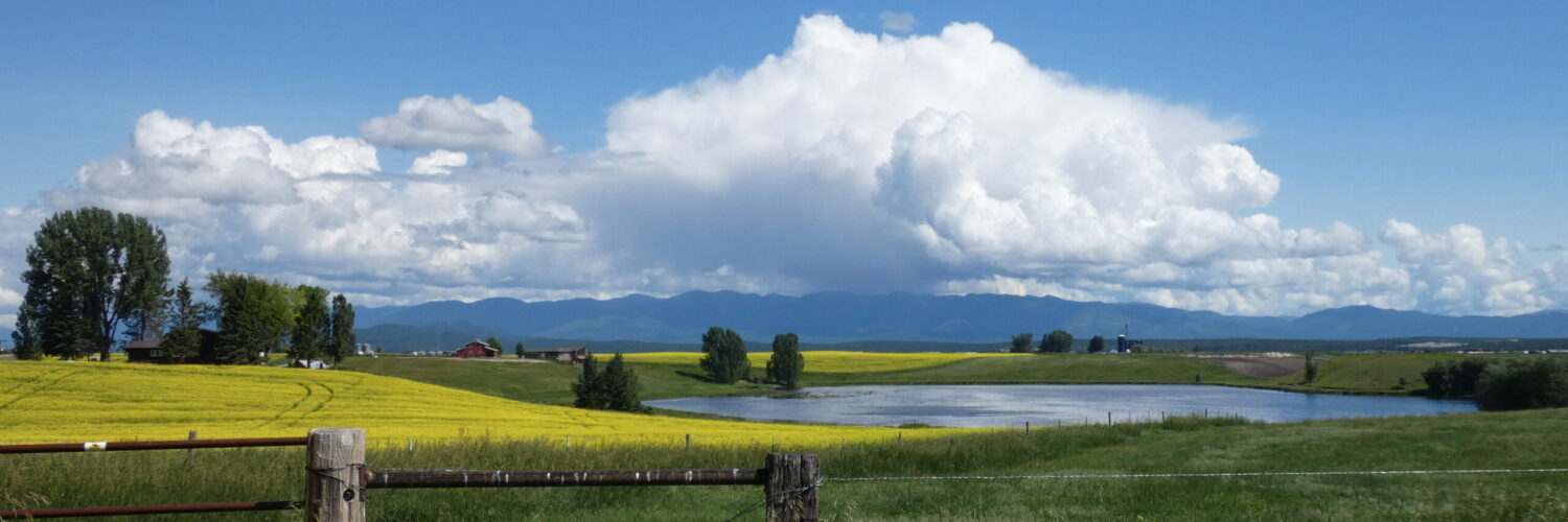
It’s easy to take water for granted here in the valley. We’re surrounded by water, with numerous streams and rivers, lakes and ponds of various sizes, and seasonal runoff from snow and rain that typically replenish the surface water that we see.
The water we drink and irrigate with here in the West Valley comes from underground aquifers–layers of permeable rocks or sediments that are saturated with water. Our shallower surface aquifers are fed by groundwater that enters the aquifers mostly through seasonal precipitation or snowmelt.
The Flathead Valley also sits directly atop a large, deep aquifer referred to in studies, appropriately enough, as The Deep Aquifer. It’s from this aquifer that our municipal water is drawn. Farms and homes also tap into the Deep Aquifer via wells for irrigation or daily use. (The city of Whitefish does not draw water from the Deep Aquifer. They draw their municipal water from Whitefish Lake and surrounding streams. See Editor’s Note, below, for clarification.)
Editor’s Note: A life long resident of the [Whitefish] community, who wishes to remain anonymous, contributed this information to this article. We’re grateful for the input and the informative clarification.
In your “ editor notes” preceding the Water Everywhere article, you state that Whitefish gets its water from the lake. There is some truth in that statement, but the real major source of water for the community is from surface water steam flows at the head of the Haskell Basin area. A reservoir holds a volume of water and creates the pressure head for the municipal system. Lake water is used to supplement summer needs in drier late summer months due to lawns and gardening irrigation — but this is an augmentation, not a year round supply. The community secured an conservation easement and watershed protection from Stoltz Land and Lumber on their property located below Whitefish Mountain Resorts and basically in the Haskell Creek Basin and drainage to protect the community’s primary source of water in the mid-2010s. Final payments to those debts occur in the next few years, but I’m not sure of exact details and don’t care to research for this note.
Just know that lake water is not the primary source for Whitefish’s water supply. It is often obvious when lake water augments our surface system, because chlorine levels increase to assure safe drinking standards — very obvious to ones’ senses.
About Aquifers
Aquifers are of two types: confined and unconfined. Shallow or surface aquifers are unconfined. They exist above an impermeable substrate (aquitard) and below a permeable layer of sediment or soil (vadose zone) that allows water from precipitation and snow melt to penetrate into the aquifer. When we speak of local water tables, we’re referring to the upper limit of the water contained in an unconfined aquifer. Wells drilled into unconfined aquifers (water table wells) are fed by pumping water from these aquifers. Unconfined aquifers can be susceptible to contamination by pollutants and agricultural chemicals carried there by groundwater percolation. The depth of the water table can vary significantly over time due to changes in precipitation, geologic changes, and human use.

Confined aquifers exist between impermeable layers of bedrock or dense silt or clay (aquitard) that do not allow surface groundwater to percolate directly down. They are typically recharged by water from a distant upland source. The Deep Aquifer in the Flathead–the source of most of our water–is such an aquifer.
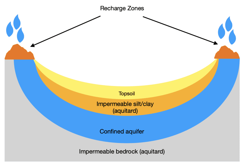
Wells drilled into deep aquifers (artesian wells) have upward pressure exerted on them up to the highest level of water in the aquifer (piezometric level) and will flow freely if the top of the well is at or below this level, as shown below:

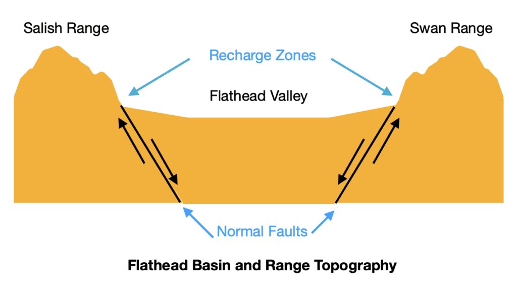
In this article from a few months ago, I talked about the underlying Basin and Range structure of the Flathead Valley. To understand our deep aquifer, it may help to review that article. Here’s a recap:
Around 170 million years ago, a large tectonic plate (the Farrallon plate) collided with the North American plate and through a process called subduction (see the article) caused the uplifting and folding that over time began the creation our local mountain ranges and valleys. About 150 million years later, the more ductile lower crust underlying the Flathead Valley began stretching east-west through tensional forces. (Again, refer to the article linked above.) The more brittle upper crust fractured as the spreading continued. Through the erosion of the rocks of the upper crust--and through the crushing and grinding of glacial activity some 15,000 years ago, the valleys became filled with gravel, rocks, clay, and silt sitting atop deeper bedrock.
This in a nutshell is how the Deep Aquifer was formed. The Deep Aquifer is a confined aquifer stretching from south of Whitefish Lake to the northern end of Flathead Lake. It sits atop a layer of impermeable bedrock, and under an impermeable layer of silt and clay overlaying the relatively looser gravel, sand and silt of the aquifer. From Montana Technical University:
The deep confined aquifer in the Flathead Valley is a thick deposit of gravel and sand, the top of which lies 75 to over 400 feet below the land surface. This deep aquifer is the most utilized aquifer in the valley, supplying high-capacity municipal and irrigation wells in addition to thousands of domestic wells.
https://www.mbmg.mtech.edu/gwip/projects/project_flathead.html#gsc.tab=0
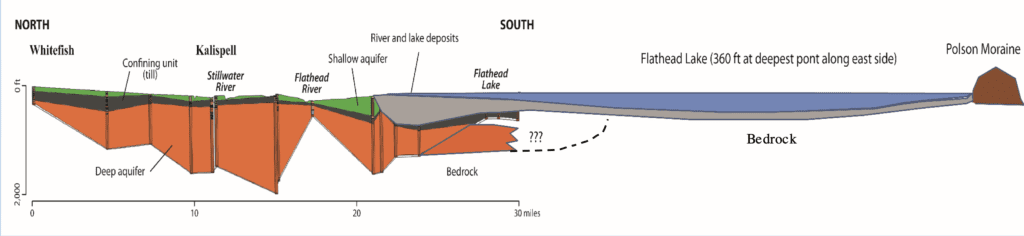
Water in the Deep Aquifer, like all water in the Flathead Valley, flows north to south, but it is not known if any of the water from the Deep Aquifer actually reaches Flathead Lake due to the structure of the underlying bedrock, as shown in this diagram from Montana Tech:
Water in confined aquifers does not typically flow as quickly or freely as it might in groundwater-fed unconfined aquifers, nor does it replenish as quickly. Water in some deep confined aquifers may have taken thousands of years to reach its current location in the aquifer.
The main source of replenishment of the water in the Deep Aquifer comes from seasonal snowmelt in our local mountain ranges entering the course sands along the valley edges and the melting of glaciers in the Swan Range and Glacier National Park. Water from melting glaciers and seasonal snowfall also recharges the aquifer through faults along the edges of our valley that are a result of our basin and range topography. Local ranges were extensively glaciated during the last ice age (17,000-15,000 years ago) as evidenced by the u-shaped glacial valleys, knife-edged ridges (arêtes), and tarns (alpine lakes), but only small remnants of glaciers remain in any location. Between 1966 and 2015, every glacier in Glacier National Park decreased in size, some by as much as 80 percent. Virtually all of the glaciers in the Swans are gone. The natural cycle of glacial growth and retreat—when new snow is added annually as existing glaciers melt—has been tilting heavily in favor of retreat without replenishment. As global warming continues, the aquifer, which relies on glacial melting and seasonal snowpack melt, is increasingly relying on snowmelt alone.
Disappearing Creeks
You may have noticed that some of the creeks in the valley wend their way through the valley only to seemingly disappear from the landscape. Spring Creek is such a creek. The currently visible part of Spring Creek, which flows year ’round, begins on the south edge of Rebecca Farms along Farm to Market Road and travels through the valley until it ends ignominiously around Ace Hardware on Meridian Avenue. On the way it passes through wetlands that are important breeding and feeding grounds for birds and other animal and plant species.
This phenomenon is caused by a combination of factors related to our valley’s topography. Streams and rivers are usually either influent or effluent. Influent streams lose water as they flow. Effluent streams gain water. Some streams, like Spring Creek, can be both at the same time, as we’ll see.
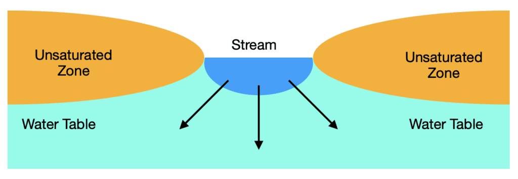
Influent streams can lose water in a variety of ways, often in combination: lack of recharging precipitation, evaporation, human consumption, percolation into an aquifer, or a drop in the water table. When the stream surface sits above the water table, it will lose water through percolation to an aquifer as shown below:
Perhaps the most well known example of an influent stream is the Colorado River, which disappears before it reaches the Gulf of California. In the case of the Colorado, its disappearance is the result of overconsumption by humans.
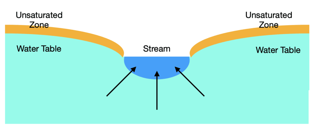
Similarly, effluent streams can gain water in a variety of ways. Being fed by tributary streams or lakes and recharging from an aquifer are the most common. (Think Mississippi River and its myriad tributaries.) When the stream surface sits below the water table, it will gain water from an aquifer:
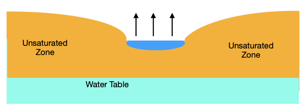
If the water table drops so low that the aquifer is no longer in contact with the stream, the stream can dry up completely unless it is recharged through precipitation. Many seasonal streams follow this pattern.
As mentioned before, streams can have both influent and effluent characteristics at the same time. Spring Creek is fed by groundwater (effluent ) and does flow year ’round. It seasonally gains water through precipitation, but its steady flow starts with groundwater. Over the course of the stream, water percolates into the surface aquifer(s) and is diverted by culverts and paved over until it disappears near Ace Hardware (influent). You can still see the old stream bed and the trees that lined it when Spring Creek flowed more freely.
Discussion
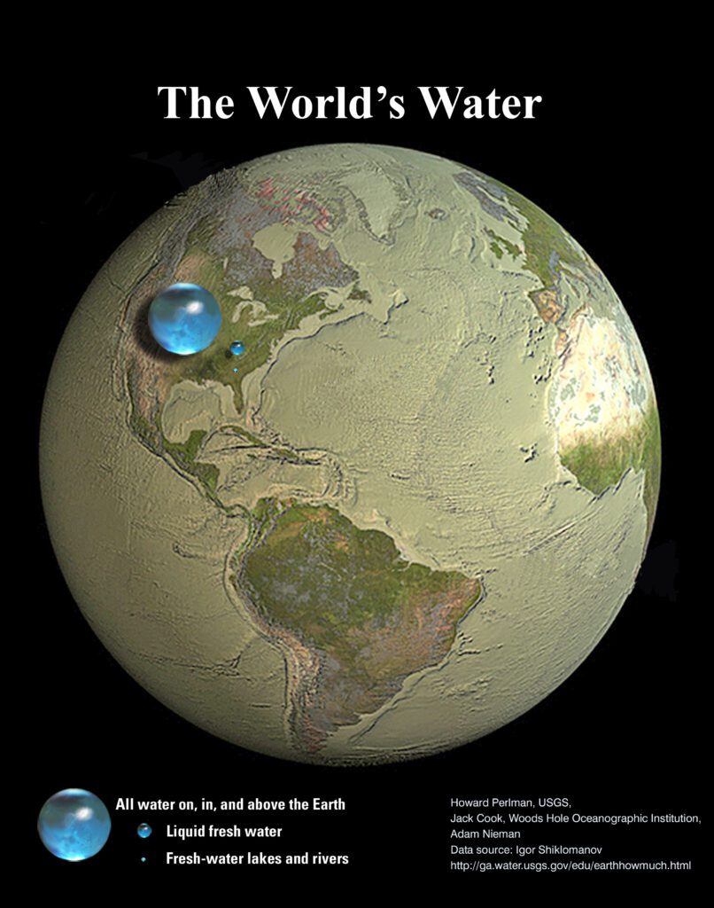
Water is the most precious natural resource on the planet. Water isn’t created anew–all of the water that we will ever have is already here, either in our oceans, in our rivers and lakes, in ice caps and glaciers, stored underground, in our atmosphere, or in the biosphere (living plants and animals). Here are some statistics from the USGS and NASA:
- All of the Earth’s water (below, on, and above ground) could be stored in s sphere with a diameter of 860 miles–the distance between Salt Lake City and Topeka.
- All of Earth’s liquid fresh water could fit into a sphere of just under 170 miles in diameter.
- All of the planet’s fresh water in lakes and rivers–accessible to humans–could fit into a sphere with a diameter of 35 miles. Not all of this water is drinkable.
- If all of the world’s water was poured on the contiguous United States, it would cover the land to a depth of about 107 miles.
- 96% of Earth’s surface water is saline.
- 3.5% of all water on Earth is drinkable, and 68% of that is trapped in glaciers and ice caps.
- 30% of the planet’s fresh water is underground.
- About 2% of the world’s fresh water is in rivers and lakes.
- If all of the water in our atmosphere fell at the same time, it would cover the world to a depth of one inch.
A visual from USGS might help:
Fortunately, water gets recycled and reused through the water cycle (precipitation, runoff, evaporation), through percolation and recharging between streams and aquifers, and through local means such as municipal water purification or desalinization. Still, access to drinkable water is becoming more scarce as the planet’s population increases and as the changing climate affects weather and precipitation patterns.
In the Flathead Valley, we’re fortunate to have access to plentiful water from the Deep Aquifer and from other surface aquifers, lakes and streams. But no one really knows how much water is stored in the Deep Aquifer or how quickly it recharges itself, nor can we accurately predict what changes may occur due to climate change. One thing is clear, though. Water is a finite resource, and access to it depends on a variety of factors that require some thought and planning based on current and future conditions that provide that access.
F or six generations we were drain .drain,drain. Talk about water Recharge and incorporating it with drainage
It’s a complicated issue for sure. We sit on a huge aquifer, but no one really knows how much water is there. We do know how the Deep Aquifer recharges, but I’m not aware of the rate at which it recharges. Do you have any insights into this issue that you could share?
[…] an article from April 2023 titled Water Water Everywhere?, I went into some detail about the way our local aquifers (confined and unconfined) are […]