Flathead Valley Hydrology Presentation

by Skip Via
skip@westvalleynaturalists.org

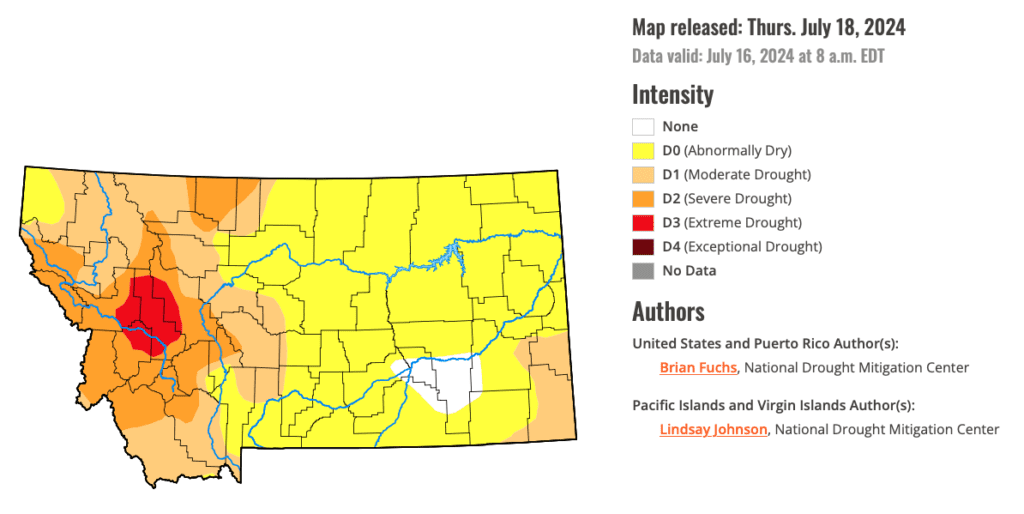
This is a recreation of a presentation given to the Flathead Audubon Society in April 2024 during the Warbler Weekend at Tally Lake. I had several goals for the presentation. One was to lay out in a very basic way the geological history of our valley–how we got here and why things are the way they are. Another was to look at some basic hydrology issues in our valley–streams, lakes, and other resources–in the context of the constant geological and developmental changes that we are experiencing, both natural and human caused. Finally, I wanted to put all of these issues into a context that might help us think about what the future holds for us in terms of our access to water, wildlife, and recreation in the valley.

This presentation intentionally raises more questions than it provides answers. I would welcome comments, suggestions, criticisms, and other points of discussion.

Continue Reading →

Hydrology Snapshot, July 2024

by Skip Via
skip@westvalleynaturalists.org

A year ago, when most of the valley was in the throes of an extreme drought, I posted an article titled Hydrology Snapshot, July 2023 in which I started the process of keeping track of some issues related to water usage, precipitation, and water management in the Flathead Valley.

It’s now mid-July 2024. We’re still experiencing drought conditions, but the severity has been downgraded to moderate/severe. Droughts are rated on a 5 point scale: D0 (Abnormally dry), D1 (Moderate), D2 (Severe), D3 (Extreme), and D4 (Exceptional). 99.62% of the Flathead is considered to be in Moderate (D1) conditions as of this writing.

Source: U.S. Drought Monitor, July 18, 2024
Continue Reading →

Hydrology Snapshot, September 2023

by Skip Via
skip@westvalleynaturalists.org

Here is a quick end-of-summer hydrology snapshot as of 9/18/23. (Compare to July 2023.)

Rainfall YTD-3.4” from average
Flathead Lake Level-36” (3’) from full pool
Hungry Horse Reservoir-168” (14’) from full pool
Streamflow, Flathead River-80 cfps from normal
Snowpackn/a
Snowmeltn/a

Despite a welcome August rain (21st wettest August on record) from the remnants of Cyclone Hilary, most of the Flathead Valley is still experiencing “moderate drought.” As of this writing, we’re experiencing the 6th driest year in 129 years of record keeping. Lake levels remain at historic lows. Streamflow in the North and Middle forks of the Flathead River are at “historic lows.” Streamflow in the Flathead River is somewhat mitigated by release from the Hungry Horse dam, which by regulation must maintain a minimum streamflow level for water leaving the dam. That release is causing the water level at the dam to drop.

Local lakes and ponds have benefitted from the August rain. Water levels are noticeably higher than they were in July, but are still far below average levels. Some of this increase is due to runoff, and some is due to the raising of the water table through replenishment of the shallow aquifers that underlie most of the West Valley area.

Compare this image to the image at the top of this page and to the image from the Hydrology Snapshot, July 2023.

The other noticeable effect of the August rain event was the immediate and dramatic greening up of local flora. And lawns.

Are We Drying Up?

by Skip Via
skip@westvalleynaturalists.org

Editor’s note: In an earlier post on our website (Water Water Everywhere?) I discussed the nature of our valley water resources. Our groundwater comes from two sources–the shallow, unconfined aquifers that are replenished by precipitation, and the deeper confined aquifer from which Kalispell’s municipal water and most of the water used for irrigation in the valley is drawn. None of our water comes from reservoirs. (Whitefish gets its municipal water from Whitefish Lake.) A review of that article might provide good context for this article.

The intent of this article is intended to stimulate thought, not to advocate for a specific viewpoint. To that end, some assumptions, disclaimers and caveats:

  • I’m not a hydrologist, climatologist, or a geologist–just an interested observer;
  • Weather can change quickly in these parts;
  • Weather and climate are not the same thing;
  • I don’t know the answers to the questions I am posing.

It’s not difficult to see what a critical force water has been in the geographical and habitation history of our valley. If we didn’t have access to abundant water resources, both above and below ground, we would not be the agricultural center that we are now. And if it weren’t for glaciers, snowpack, and rushing rivers and streams, the landscape around here would look a lot different. There probably wouldn’t even be a place level enough with sufficient soil to farm at all.

Continue Reading →

Hydrology Snapshot, July 2023

by Skip Via
skip@westvalleynaturalists.org

My intention with this post is to begin a regular documentation of the local effects that hydrological issues have on life here in the valley.

This post from last month–Water Water Everywhere?–discusses some of the hydrological factors involved in how we access water resources for drinking and agriculture here in the valley, including a discussion of the water table and the Deep Aquifer, from which most of our water is drawn. The distinction between the water table and the Deep Aquifer is important. Rainfall, which can alter the local water table either by its presence or absence, does not affect the amount of water in the Deep Aquifer. Please refer to that article for more information.

Here’s a quick Flathead Valley hydrology snapshot from July 4, 2023:

Rainfall YTD5” (avg 9.72”)
Flathead Lake Level12” below 23-year median,
9” below full pool
Valley Sreamflow60% below average
Snowpack86% of average
SnowmeltFastest in 30 years
Continue Reading →

West Valley Geology Tour

by Skip Via
skip@westvalleynaturalists.org

Welcome to a virtual tour of some of the Flathead Valley’s prominent (and some not so prominent) geological features, courtesy of Google Earth.

This tour is a companion piece to several articles that have appeared elsewhere on our website:

This inspiration for this project came largely from the work of Dr. Lex Blood, professor emeritus, Flathead Valley Community College, for his extensive (and clearly heartfelt) efforts to make the geological history of the valley accessible to everyone. Thank you, Lex.

Continue Reading →

Water Water Everywhere?

by Skip Via
skip@westvalleynaturalists.org

To take a virtual tour of the West Valley area, click here.

It’s easy to take water for granted here in the valley. We’re surrounded by water, with numerous streams and rivers, lakes and ponds of various sizes, and seasonal runoff from snow and rain that typically replenish the surface water that we see.

The water we drink and irrigate with here in the West Valley comes from underground aquifers–layers of permeable rocks or sediments that are saturated with water. Our shallower surface aquifers are fed by groundwater that enters the aquifers mostly through seasonal precipitation or snowmelt.

The Flathead Valley also sits directly atop a large, deep aquifer referred to in studies, appropriately enough, as The Deep Aquifer. It’s from this aquifer that our municipal water is drawn. Farms and homes also tap into the Deep Aquifer via wells for irrigation or daily use. (The city of Whitefish does not draw water from the Deep Aquifer. They draw their municipal water from Whitefish Lake and surrounding streams. See Editor’s Note, below, for clarification.)

Continue Reading →